Infrastructure geospatial intelligence

Global infrastructure data, mapped with precision.

Littoral Data turns public geospatial intelligence into structured infrastructure datasets — layering satellite imagery, open infrastructure records, place data, and LLM-assisted classification to map ports, terminals, quays, storage tanks, airports, and heliports.

Analysis-ready data products for maritime, energy, logistics, insurance, and geospatial intelligence teams.

Port infrastructure layer

A first look at the ports map.

The first Littoral Data product focuses on commercially relevant port infrastructure, organized as a structured geospatial layer for maritime intelligence workflows.

Demo map

Ports, terminals and quay-level infrastructure in one geospatial view.

Littoral Data ports map demo showing geospatial port infrastructure coverage
Global coverage Designed to include commercially relevant ports, terminals and long-tail infrastructure.
Polygon-first Built for geofencing, AIS enrichment, port-call detection and infrastructure analysis.
Analysis-ready Structured for delivery in practical geospatial formats with clean categories and identifiers.
Data products

Built for teams that need more than coordinates.

Littoral Data provides structured datasets with stable identifiers, categories, hierarchy, evidence fields, and geofenced polygons where they matter most.

01 / First release

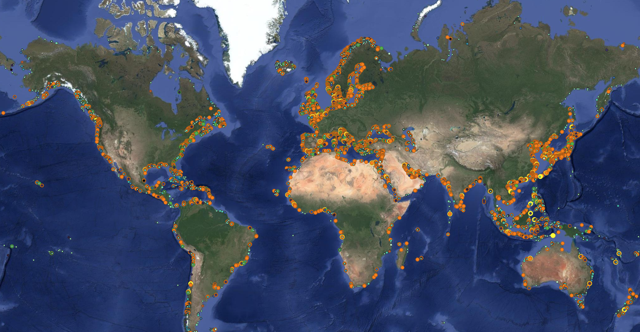
Port Infrastructure Layer

A global port database designed for maritime analytics, AIS enrichment, congestion intelligence, infrastructure mapping, and due diligence on nearby industrial assets.

  • Port polygons
  • Terminal and quay structure
  • Categories and hierarchy
  • Stable identifiers
  • City and country attribution
  • OSM and public-source context
  • Analysis-ready delivery formats
02 / Roadmap

Storage Tank & Fuel Layer

Mapped storage tanks and fuel infrastructure for energy intelligence, bunkering analysis, industrial exposure, and logistics use cases.

  • Tank locations
  • Tank farm structure
  • Fuel and bunkering context
  • Industrial site relationships
03 / Roadmap

Airport & Heliport Layer

Broad airport and heliport specifications for logistics, offshore operations, emergency response, infrastructure analysis, and regional accessibility mapping.

  • Airports and heliports
  • Operational categories
  • Broad specifications
  • Infrastructure relationship mapping
Methodology

Public intelligence, layered with machine review.

Littoral Data is built from a repeatable data-mining pipeline: start from public geospatial signals, cut candidate areas into satellite tiles, ask an LLM to identify infrastructure patterns, then enrich the resulting points with administrative and open-map context.

01 / Source

Public signals become candidate locations.

We begin with public geospatial inputs and open infrastructure indicators: coordinates, map features, place records, port and industrial tags, roads, wharfs, quays, storage tanks, substations, quarries, and nearby named sites.

02 / Observe

Satellite tiles provide visual evidence.

Candidate locations are converted into standardized imagery tiles so each location can be reviewed consistently, one tile at a time, with preserved coordinates, bounds, imagery metadata, and processing history.

03 / Classify

LLMs detect infrastructure patterns.

The model reviews each tile for large ports, terminals, shipyards, quay structures, storage and industrial infrastructure, returning structured labels and pixel coordinates instead of free-form prose.

04 / Enrich

Open map context turns detections into data.

Positive detections are converted back into latitude/longitude and enriched with OSM, reverse geocoding, infrastructure proximity, administrative attribution, named roads, operators, brands, and nearby industrial signals.

05 / Review

Industry experts validate the signal.

A human reviewer with maritime and infrastructure knowledge checks the evidence, catches false positives, interprets edge cases, and turns machine detections into commercially usable intelligence.

The output is not a screenshot. It is a structured evidence layer.

Every record is designed to carry both a location and the public-intelligence context around it, so users can filter, audit, prioritize, and integrate it into their own workflows.

  • Visual evidenceSatellite-derived tile, imagery metadata and tile bounds.
  • LLM outputInfrastructure label, center pixel, confidence-style outcome and short description.
  • Public contextOSM features such as quays, docks, wharfs, tanks, power, roads, quarries and industrial zones.
  • Operational fieldsCoordinates, city, region, country, stable identifiers and analysis-ready export formats.

Infrastructure intelligence starts with knowing exactly where things are.

Ports are not just points. Terminals are not quays. Tanks, airfields and industrial sites only become useful when they are mapped, structured, categorized and connected.
Approach

Built to scale beyond manual mapping.

Global and exhaustive

Designed to move through large candidate sets systematically, including the long tail of commercially relevant infrastructure.

Cross-dataset intelligence

Designed to connect ports, tanks, terminals, airfields, industrial sites, energy assets and adjacent public-map signals.

Fast delivery

Packaged for teams that need usable geospatial data quickly, with the pipeline preserving progress and evidence as it scales.

Team

Built by maritime and SaaS operators.

Littoral Data combines maritime intelligence experience with customer-focused SaaS and logistics execution.

Yvan Gelbart, Founder of Littoral Data
Founder

Yvan Gelbart

7 years of experience in maritime intelligence, building structured data products for operational and commercial analysis.

Linette Flores, Marketing & Customer Support at Littoral Data
Marketing & Customer Support

Linette Flores

5 years of SaaS and logistics experience, supporting marketing, customer conversations, and practical adoption of complex data products.

Use cases

For operational, commercial and risk intelligence.

Littoral Data supports teams building products and analysis around the physical infrastructure behind global trade, energy, transport, and maritime operations.

AIS / 01

Port-call and vessel-event detection

Use port, terminal and quay geofences to enrich AIS data and identify where vessel activity actually happens.

ENERGY / 02

Storage and bunkering intelligence

Connect maritime infrastructure with nearby fuel, tank farms, oil terminals, bunkering zones and industrial assets for richer energy and logistics analysis.

RISK / 03

Infrastructure exposure mapping

Support risk, insurance and monitoring workflows with structured layers of commercially relevant infrastructure and public-source evidence fields.

Want to test the first dataset?

Request a demo to discuss sample coverage, delivery formats, data structure, and early-access use cases for Littoral Data.

Ask for a demo →